Routing Component
Offline access to distances and routes.

Routing Component
Routing Component is part of our AtoBviaC distance calculations software range. The AtoBviaC Routing Component is a software component, providing offline access to distances and routes from the comprehensive AtoBviaC route network. You can easily add value to your applications by integrating the component into your own software. The functionality of the Routing Component is specifically to support offline scenarios - typically for use on a vessel as part of an end-user application.

Advantages of Routing Component
Cost effective
Our annual subscriptions are priced based on the number of distance calculations rather than the number of users.

Accurate & realistic distances
Route legs are reviewed by experienced Mariners to ensure accurate and realistic calculations.
Precision
Easily obtain high-precision route way points for total accuracy.
Marine Distance Tables
Greener results
Total control
Comprehensive coverage
Updates
The Distance Tables used in Routing Components are updated and expanded regularly to add new ports and to adjust routes and distances to reflect changes in regulations, IMO Ships' Routeing, non-IMO routing schemes, Notices to Mariners and environmental factors. We issue new releases every two to three months. The updates are included in the annual license fee. Updates are downloaded and installed over the internet.
Included features
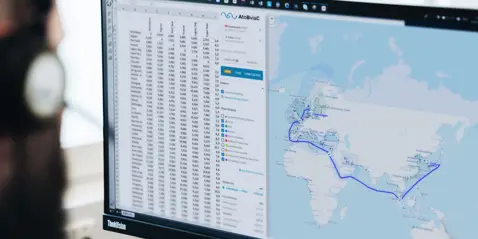
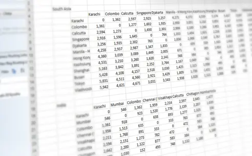
Accurate distances, the ability to create multi-leg voyages using over 3300 'distance table' ports with full control over routing between ports.
All the Marine Distance Tables products from AtoBviaC include the following:
- Fully respect all mandatory and recommended traffic separation schemes (as a result, the distance between ports A and B is not necessarily the same as from B to A)
- Allow the user to change the routing between ports
- Include comprehensive coverage of oil, dry bulk, gas and container ports
- Deliver the shortest reduced environmental impact route as a default
- Use industry approved formulae for calculating the distances for Rhumb Line and Great Circle distances
- Determine the exact position of both the starting and ending point of a voyage - in a large port this will be a central safe position within the port; for an offshore terminal it will be the waiting area for that terminal; for a single berth it will be a position just off the berth
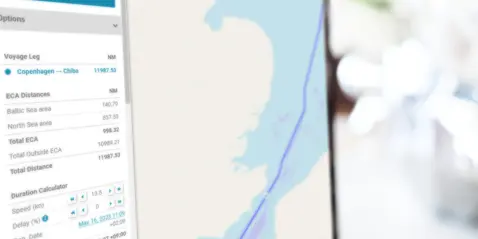
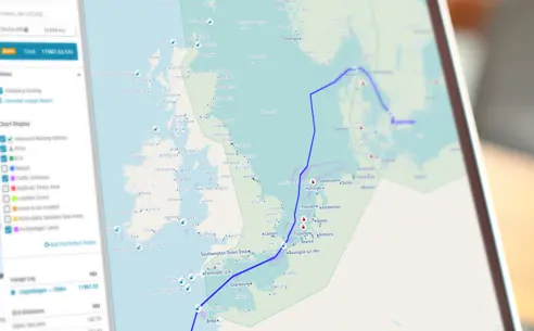
- Offers the ability to calculate distances within ECA (Emission Control Area) zones
They provide a graphical display of:
- Emission Control Areas - Shows currently in force and shortly to be implemented ECAs and calculates distances within those areas
- Marpol - identifies special areas as defined by the Marpol convention
- JWC Piracy - displays the latest Joint War Committee recommendations on Piracy, Terrorism and Related Perils
- Loadlines - Shows international loadline zones and calculates distances within the zones
AtoBviaC applications available
Do you need help?
AtoBviaC has its own website with full product and purchasing details. Click here to visit AtoBviaC.com
Go to AtoBviaC.com